all Travel Business All Travel Businessall Travel Business

Search This Blog

Pages

Showing posts with label Trekking. Show all posts

Humla - The Unchartered Nepal

(for more pictures click Humla...)

Humla is the most remote district in Nepal, and one of the poorest. It's also the most sparsely populated part of the country. The combination of state neglect and bad press (when did you last read something good about Humla?) means there are few tourists, and you'll meet most of them in or headed to the border town of Hilsa, a stepping stone to Mount Kailash in Tibet. All the better for you to enjoy the wonders of Humla at your leisure. You won't regret it; locals will appreciate the fact that you have sidestepped the more obvious destinations in the Everest and Annapurna regions. There are not many jobs going in Humla, and your visit could well make the difference between a family migrating to India or the Gulf and their setting up a profitable teahouse on the trail.


The trek
Humla is a land of extremes. Simikot, spread out on a flattened hilltop amidst a colourful harvest expanse of fields, lies at 2900m. From here the newly designated Great Himalaya Trail follows the old salt trading route to Tibet between the towering green monoliths of the sisnoo-infested Hindu midlands up to the arid expanses of our version of the Tibetan plateau, all the while accompanied by the roaring quicksilver of the magnificent Karnali. You'll pass occasional tight clusters of mud-packed, flat-roofed houses where women with heavy gold & silver jewellery embroidered with colourful beads belie the obvious, all-pervading poverty. Thakuri men lead flocks of long-haired, impressively horned goats up and down the muddy trail on their way to and from Tibet.


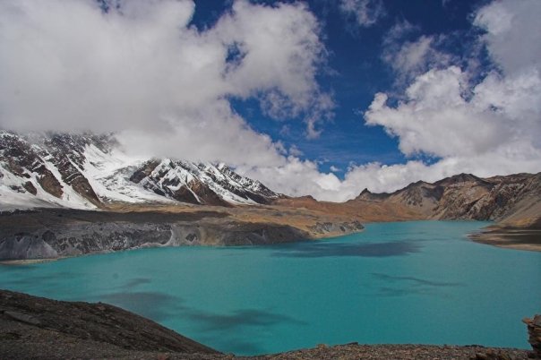
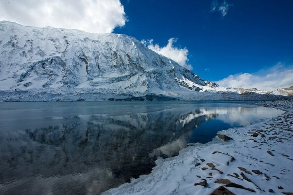
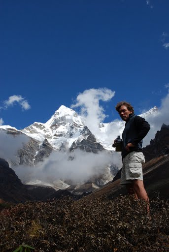
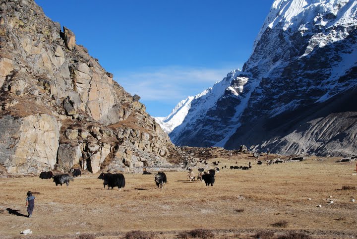
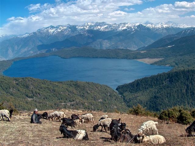
As you approach Hilsa and the northwestern border, the landscape becomes drier, and the context, Buddhist. Look out for the contrasting monasteries at Yalbang and Tumkot. After the desolate Tibetesque views around Hilsa, the Limi Valley, approached through amazing red rock scapes haunted by blue sheep and huge vultures, is as isolated as anything you will see in Nepal. There are three medieval stone villages here, a day apart, with a must-see monastery at Halji. You'll then walk through a dessicated high-altitude landscape (and through the bone-numbing cold of the Ling Chu River) to nestle in the glacial valley below the Nyalu Pass. The aquamarine Tshom Tsho lake on the way is all the more remarkable for the contrast with the burnt sienna of the treeless expanses. A tough climb to 5000m, then back down into an astonishingly verdant birch and pine forest chittering with birds and a campsite in the shadow of a massive rock face.


How to get there
Take a bus or plane to Nepalganj, then a plane to Simikot, district headquarters of Humla. Apparently you have a better chance of getting a flight to Simikot  if you travel from Nepalganj to Birendranagar, Surkhet (through Bardia National Park). Once you overcome the logistical and weather-related problems that may occur if you are travelling at the end of monsoon, just start walking. If you do get stuck waiting for a flight, you can explore Bardia National Park from either Nepalganj or Birendranagar, but I'd recommend the latter for little visited sights such as Kakrebihar, where the mossy ruins of a medieval temple in the midst of a forest make for an unexpected, atmospheric day trip.


Itinerary
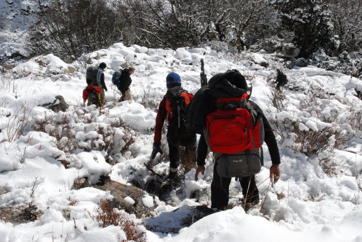
Your 12-day trek beings at Simikot, from where you head northwest along the Karnali River. We stopped for the night at Dharapuri, Kermi, Yalbang, Tumkot and Hilsa, but the location of teahouses or the preferences of your camping group may vary. From Hilsa, cut back through the Limi Valley, stopping at campsites at Manepeme, Til, Tatopani (non-negotiable, as it really does have a hot spring you'll appreciate at the end of a dusty day's walk) and Talung. Over and up the 5000m Nyalu Pass and down into the birch and pine forests to a campsite alongside the Sallu River, then back to the trail to Simikot, stopping only at Dhandkermi, and you have a perfect circuit in less than a fortnight.


What to take
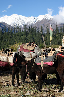
The usual trekking gear (good boots!), and don't forget to keep warm. Nights at 4000 metres can be freezing cold (but brave the winds to step out of your tent for superlative views of an exploding Milky Way). The usual way to do it is to log onto a camping expedition, but it is possible, with some prior research, to find lodging at some of the new teahouses along the route. Take a sleeping bag and if you want to go solo in the Limi Valley, you'll need a tent and extra food, as very little will be on sale here, and not everyone speaks Nepali, either. Take extra batteries for your camera, as it's sometimes hard to get a recharge along the way.


Room and board
If travelling with a camping group (Janga Bahadur Lama of Firante Travels, www.firante.com, organises such groups), you'll get a composite price, including flights to Nepalganj and Simikot. If going solo, keep in mind that while food is much more basic than on the Annapurna and Everest trails, and thus cheaper, accommodation in teahouses is both more basic and more expensive. Expect to spend about Rs 200 per dalbhat and up to Rs 500 for a bed. If you want something in between dalbhat (teahouse standard) and pasta (camping special), try the local cuisine, including tsampa (roasted barley flour that is great as porridge), nettle soup, thukpa, buckwheat pancakes, and Humli apples. You won't get to pick out your 'local chicken' here, but might come across jaw-numbing yak sukuti or pungent chyangra. You may want to wait till you approach the Tibetan border before you go wild on the Lhasa beer (though the altitude deserves respect), which gets cheaper as you go along. Personal recommendation: barley (uwo) chyaang for a donkey kick better than what you get out of its Kathmandu counterpart. 


Travel Journey by: Rabi Thapa

My Zimbio

The Tilicho route - exploring the Annapurna Region

(for more pictures click Tilicho...)

The Route
The Tilicho Tal route between Manang and Marpha is a spectacular but much tougher alternative to the standard Thorung La route. In the past this trek has been considered off limits, being part of a military training area.
However, recently it was realized that the restrictions apply only to part of the area and so it is still possible to trek there without entering the restricted region. Very few people realise this.
The route crosses three 5000+m passes and requires two to three nights camping. The trail itself is infrequently used and traverses some difficult terrain including steep, unstable scree slopes. On the Manang side the trails to the lake are gradually being improved and there is a semi-operational lodge at the base of the first pass meaning that you could visit the lake as a side-trip without camping. This side trip provides good acclimatization for crossing the Thorung La.


Which route - Thorung La or Tilicho?
Tilicho is a far more committing route. Experience-wise, they are different but, much as I hate to admit it, both are equally spectacular. So essentially Tilicho has extra kudos among discerning trekkers and the "I did it different" factor but Tilicho does mean camping so it is more of a remote wilderness experience.


Acclimatization
Because you have to sleep at 4900m you need significantly more acclimatization than for the Thorung La route (where you sleep at a maximum of 4200m, at Thorung Phedi, or 4600m at the new Thorung Phedi Base Camp lodge). Your acclimatization, at an absolute minimum, should include staying the night at either Ghyaru or Ngawal (staying at both is far better) on the high route from Pisang to Manang, a night each at Manang or Khangsar and the gompa above Khangsar before staying at Meadow Camp. Even then you are only acclimatized to sleeping at around 4300m and jumping to camping by the lake shore at 4900m will be uncomfortable for some people. Carry Diamox and consider using it from Meadow Camp.
For some acclimatization and a view of the route climb to the two lakes high above Manang. Herzog crossed on the frozen lake (and had fun persuading his porters) to save the arduous higher route around. From late December the lake is frozen enough to cross, with care!


Gear

If crossing from December on at least one of the members should have crampons and an ice-axe for crossing frozen streams. If planning to cross the lake when frozen all members should have crampons and it would be wise for the first person to be at the end of a long rope. Note that falling into a partially frozen lake is serious, often fatal. Test the ice and be prepared to cross the middle pass if in doubt. The lake usually begins freezing over mid-November and may be frozen enough for passage from mid-December, perhaps slightly earlier.


Names
Cho or Tso means lake so it is redundant to call it Tilicho Lake. The locals don't call the route Tilicho La, although this is a possible name for the route. More than this, I haven't yet found out.


Seasons
This is route should only be attempted when mainly snow-free and during fine weather, ie October to late December and perhaps May - June. If the winter snows have been light then trekking across in January to April may be possible if exceptionally well prepared for snow and cold.

Trail Notes

To Manang
See Trekking in the Annapurna Region or other trekking guides. Allow 6 to 8 days from Kathmandu.

Day Trips from Manang
There are a number of good day trips out of Manang to aid acclimatization but the best isn't mentioned in the guide books. Only attempt this in good visibility since there is no major trail.

The Lakes above Manang
From Manang take the trail in the direction of Braga. Leave this trail after crossing the first stream out of Manang. Head up the ridge on steep trails past a gompa and other buildings. Continue heading up on vague trails. there is a kharka, a collection of stone shacks part way up, although you may miss these. Continue up, bearing slightly right, if in doubt. You don't want to follow or get close to the stream that you first crossed, just out of Manang. Bear right (north) and eventually come across a small lake, really a pond and a kharka. The route is more obvious now. From the second, larger lake climb the spur to the right for fabulous views.

Khangsar ~ 3800 m
There are two routes to Khangsar. The more usual route is part way through Manang descend to the bridge that crosses the Marsyangdi but stay on the Manang side and head up-river past where the Khangsar Khola enters and cross on the bridge there. After an initial steep slope there's a broad track to Khangsar.
ALWAYS ask local advice for the trail up to Tilicho, and ask if the lodge is open or if someone can come up. Leaving Khangsar again there are two routes, the higher more torturous trail via the Gompa which begins at the far end of the village and the lower, easier route that descends to the river from the centre of the village. The lower route provides less acclimatization and you should check with locals that the bridges are in place, and if not, you must take the high route.

Note
The lower route is not the safer and the trail doesn't stay on the Khangsar side of the khola (stream). You must cross! This trail on the other side is being developed.

Meadow cap ~4200 m
(I didn't find the traditional name for this area). Traditionally a summer grazing area, in 1994 the beginnings of a lodge were built here. In fall 96 two ladies from Khangsar spent the season up here. They provided simple food but no bedding or mattresses. As this side trip becomes more popular more facilities will be provided. In 1999 the lodge was still little developed but the locals were getting more serious about building a lodge at Tilicho itself, which means the meadow lodge would be vital to the plan.
Around here and higher you can find blue sheep grazing. It is also snow leopard territory. I was lucky enough to see one here while sleeping out on a small knoll. It walked along the trail, within 10m of me!
An obvious path leads to the zig-zag route up the huge moraine. Part way up the route divides, although the cairned junction is easy to miss. The route straight up is steeper and now disused. The other path contours up to a slightly lower pass, a slightly longer route. Over the crest is the lake framed by the impressive Tilicho Peak 7134m. Both trails are exposed and steep. If thickly covered with snow it is mountaineering terrain and the avalanche risk is correspondingly high.

Tilicho Lake 4900 m
It is an area of rough and wild beauty. The 4km by 1km lake rests at 4900m. There is no visible outlet, a fact that has confused Kathmandu map makers. The southern shore is a glacial wall pushing in from the south, while a segment of the north shore is a magnificent sheer cliff.
Once tourism becomes more sophisticated sea kayaks would the ideal method of crossing the lake and eyeballing the glacial walls, Alaskan style.
Despite the dotted trails on most maps you CAN'T walk around the northern shore of the lake unless you can walk on water or ice. Never attempt to traverse the southern shore-glacier under Tilicho Peak, although there is a faint trail - it's raked by avalanches and is particularly rough country. At least one trekking party has had people die here.
If camping near the shore make a deep toilet (ie half a metre for 5 trekkers) well away from the lake (100m or more) and cover with heavy stones on leaving. This region was still pristine in fall 1996. Please personally double-check that you or your crew have left your camp site so clean that you wouldn't know anyone had stayed there.
From around the middle to late December into May the lake is frozen enough to walk on, but test the thickness well away from the shore. 100mm should be considered the minimum, although in theory 40mm can support a dog team and sled. When crossing don't stick to the shore since rocks occasionally put holes in the ice there and the sheer rock wall reflects sunlight, leaving the ice weaker near it. Note also that ice thickness will vary so be particularly watchful early and late in the season. Once across ascend the obvious gully to meet the alternative pass trail.

view of Tilicho Lake


The pass to the north ~ 5300 m
When the lake isn't frozen or your nerves aren't up to it, the alternative is to cross another pass. From near the lake head north-east up to the small but obvious notch, and to new vistas. There is no path from here, only a few cairns but the route is straightforward enough. Over the minor pass eventually head down a large gully (good scree-running) that leads to the other end of the lake. Well into this gully some paths sidle off to save descending the last part although staying on the valley floor may be easier.
It is possible to camp at the head of the lake otherwise head up the obvious gully. As this runs out there's a choice of routes: crossing the rubble to the south-west on difficult terrain leads to the 5315m Meso Kanto (pass). This drops steeply to a high kharka suitable for camping then the military base at Kaisang. The more usual route that avoids the military camp and the restricted area briefly ascends around to the north to the alternative pass, marked by a few cairns, and there is a small plaque on top. Initially the descent is steep and in bad snow conditions might require a rope. Descend generally around to the north and eventually pick up a small trail. The first camping spot is well down and often lacks water.
Further down are shepherds camps and a good trail to Thinigoan, visible from the pass region.

Suggested Itinerary
From Pisang village: Pisang village 3200m (lower) 3300m (upper) Ghyaru 3670m and/or Ngawal 3657m Braga 3450m or Manang 3540m Optional extra day at Braga or Manang Khangsar ~3800m Khangsar gompa ~4000m Meadow Camp ~4200m Lake camp 4900m Kharka camp Marpha/Jomsom

Source: - "TRAILBLAZER" book by "Jamie McGuinness"

My Zimbio

Mt. Kanchenjunga - Trekking and Expedition

(for more pictures click Mt. Kanchenjunga...)
Mount Kanchenjunga, one of the world's most spectacular mountains, is renowned as the queen of mountains. Kangchenjunga, the third highest peak on the planet, can boast of varied ecological zones, from the subtropical land to glacial wilderness. Mighty Kangchenjunga glacier is the most famous attraction of Kanchenjunga. Great valleys, encircled by high peaks, are another feature of Kanchenjunga. Mt. Kanchenjunga is a massif with its highest peak reaching 8,586metres. It is encircled with dozens of peaks, each of them competing with their queen. 


It is situated in eastern part of Nepal at 8598m. It was first climbed by a British team in 1956. It is an enormous mountain mass, and many satellite peaks rise from its narrow icy ridges. It is located on the border of Nepal and Sikkim, just 46 miles northwest of Darjeeling. It is the most easterly of the great 8,000 meter peaks of the Himalaya. The peak consists of four summits.


The west summit, Yalung Kang, is 8420m high and some people classify it as a separate 8000m peak. Three first Westerner to explore Kanchenjunga was the British botanist JD Hooker, who visited the area twice in 1848 and 1849. Exploration of the Skim, side of the peak continued with both British and pundit explorers mapping and photographing until 1899. In that year a party led by Douglas fresh field made a circuit of Kanchenjunga and produced what is still one of the most authoritative maps of the region. The Japanese now took up the challenge and mounted expeditions in 1973, 1974 and 1976 during which they climbed Yalung Kang. A German Expedition climbed Yalung Kang in 1975, and in 1977 an Indian army team mounted the second successful expedition to the main peak of Kanchenjunga.

view of kanchenjunga


The route (North Face) is definitely the safest, although not the easiest. Climb of Kanchenjunga begin from a charming base camp in the meadows of Panorama at 5,180 m. First challenge is to fix lines up 900 m of intricate mixed climbing to the North col. This provides the most challenging climbing of the expedition. Once creating a lifeline to and from the North Col you can begin the long process of establishing three camps up the long and complicated North ridge. Using Sherpa support and oxygen, you can move at a systematically slow velocity higher and higher up the mountain. This is a highly satisfying climb for the expert Climbers.

Fast Facts
LocationFar-east Nepal
Altitude8,586 metres (28,169 feet)
Significance3rd Highest Peak in the World
SeasonSeptember to December, early February to late June
Peaks
  • Kangchenjunga Main (8586 m/ 28,169 ft)
  • Kangchenjunga West (Yalung Kang) (8505 m/27,904 ft)
  • Kangchenjunga Central (Middle) (8482 m/ 27,828 ft)
  • Kangchenjunga South (8494 m/ 27,867 ft)
  • Kangbachen (7903 m/ 25,925 ft)


Trekking Route To Kanchenjunga
The long trekking trail to Kangchenjunga takes one through some of the country's most pristine forests. The region is an ideal place for the tourists who desire for some time in seclusion. The following is a possible day-to-day trek to Kanchenjunga.

Day 01: Fly from Kaathmandu to Birathagar/ drive to Basantpur (2200m)

Day 02: Trek to Chauki (2700m)

Day 03: Chauki / Gupha Pokhari (2930m)

Day 04: Gupha Pokhari/ Nisum (2000m)

Day 05: Nisum / Dovan (921m)

Day 06: Dovan / Chirwa (1270m)

Day 07: Chirwa / Sekhathum (1660m)

Day 08: Sekhathum / Amjilassa (2510m)

Day 09: Amjilassa / Kyapra (2730m)

Day 10: Kyapra / Ghunsa (3595m)

Day 11: Ghunsa rest

Day 12: Ghunsa / Khambachen (4040m)

Day 13: Khambachen / Lhonak (4785m)

Day 14: Day trip / Pangpema

Day 15: Pangpema / Khambachen

Day 16: Khambachen / Ghunsa

Day 17: Trek around Glacier (up to 5540m, if you want) / high camp

Day 18: High camp / Ramche

Day 19: Ramche / Tseram (3870m) back to Ramche

Day 20: Ramche / Amchekhola

Day 21: Amchekhola / Ponphe

Day 22: Ponphe / Kande Bhanjyang

Day 23: Kande Bhanjyang / Lal Kharka

Day 24: Lal Kharka / Taplejung

Day 25: Taplejung / fly Kathmandu /transfer hotel

Highlights 
Although the whole trekking trail to Kanchenjanga is adventurous and brimming with thrill, there are certain spots which are unmissable. Few of them are cited below:
  • Wonderful glaciers to trek like Yalung Glacier
  • High challenging mountain passes
  • Rhododendron forests
  • Opportunity to meet native Nepali communities such as Sherpa, Limbu, Rai and Gurung

Tit Bits 

  • Kanchenjunga is less explored by foreign visitors and lies shrouded in mystery.
  • Some features of the walk are pleasant villages in the high regions, glorious mountains and abundant wild life.
  • The wildlife at Kanchenjunga includes musk deer, blue sheep and for the believer, the Yeti!
  • Magnificent views of Mt. Everest, Makalu and Kanchanjunga massif make the trip memorable.
  • Soaring peaks, the Yalung Glacier and a wide variety of natural vegetation and agriculture areas can be seen in this region.
  • Kanchenjunga is located in the extreme northeast corner of Nepal bordering Sikkim (an Indian state) to the east and China to the North.

How To Reach The trek to Kanchenunga begins at Tumlingtar or Taplejung that is accessible by air or by road through Ilam or Basantpur.


My Zimbio

Rara --- The beautiful and biggest lake + Rara National Park


(for more picture click Rara...)


Rara Lake (2980 m) lies in the remote Karnali region in the north-west of Nepal and is centerpiece of Rara Lake National Park. Rara Lake is Nepals largest lake and is a clear blue mountain lake with juniper, spruce and pine trees along its shores and snowcapped peaks in the distance. We fly in to Jumla and the first part of the trek takes us through forests and over alpine meadows with herds of sheep and goats. After three days we reach the stunning Rara Lake with fantastic views of Dolpo and Tibetan mountains across the deep blue water. We spend a day exploring the area with abundant wildlife and enjoy the quiet beaches and the views. The four day return trek to Jumla takes us through remote villages and alpine pastures with great views of the mountain ranges on the border to Tibet and southern part of Humla.


Trekking in Rara Lake offers the best scenery on the north-western most side of Nepal. Within its confines lie the Rara national park, the smallest park in Nepal, where in turn the country's largest lake, the Rara Lake can be found (10.8 sq. km. At 2,990 meters). Considered one of the finest parks in the world, Rara National Park abounds in coniferous forest and is the ideal habitat for the musk deer, Himalayan black bear and other faunae. The Danfe (Impeyan Pheasant) the national bird of Nepal, flies above while a variety of fish, the snow trout, inhabit the Rara lake. Adding charm to the region are its generally open-hearted and friendly people. The trek can begin in Jumla (over an hours flight from Kathmandu) or from the nearer Nepalgunj.

Rara is a good destination point for trekking in the west. The trail is very much "off the beaten path" and affords glimpses of culture and scenery very different from those in the rest of the country. The centerpiece of the park is the biggest lake of Nepal. Along mountain paths and a series of picturesque villages, one reaches the magnificent banks of Rara lake. The park includes Trans- Himalayan valley with high ridges covered with forest and alpine pastures.


view of Rara


When is the best season?
The best season for this trek is half of February to First week of June and September to early December.
 

Half of February to First week of June: From the half of February until the first part of June temperatures are relatively warm, 10° to 15° warmer than in the fall. Mornings are bright and clear with the air slowly becoming hazier as the day progresses. The rhododendron forests in springtime are spectacular, with color displays that are "Himalayan" in beauty. June is warm and green with many fewer people - the sense of solitude is much greater than other seasons.

September to half of December: September to early December is an ideal time for the best mountain  views. The days are typically sunny and clear with moderate temperatures and the evenings are usually quite cold.
Note: July to August is the Monsoon period in Nepal. However, it is possible to do trekking in rain shadow area like Mustang, Rara, Dolpo, Annapurna circuit, Lantang valley, Everest base camp and Gokyo valley respectively.

How  can you trek in Rara Lake area ?
Rara Lake Trekking can be organize only camping (Tented Camp). On a camping trek you will sleep in tents. The staff includes a guide, cook, Sherpa and sufficient porters to carry all trekking gear. Even if you have never camped before, there is no need to worry that you won’t enjoy the experience. The tents we provide are roomy, the sleeping pads/ mattresses are comfortable and international style food of a high standard is freshly prepared and served. On all of our treks a bathroom tent is provided as well as a dining tent with tables and camp stools, providing a cozy, comfortable atmosphere to eat and chat with fellow trekkers during the evening.
 
How Camping Trek is Operated? 
In a typical Camping Trek, day starts around 6 a.m. with a cup of hot tea or coffee followed by a bucked of warm water for their washing and cleaning. After packing up their stuff and daypack, the trekkers are requested to leave their camp and meet at the dinning table for breakfast. The trek started around 7.30 - 8 a.m. and the kitchen staffs go ahead of the group.
Our well trained staff pack all camping equipment and gears and the porters carry them to the next camping site. The trekkers should carry only personal belongings that they may need for the day like water bottle, rain gear, camera, etc.


The Trekkers can decide on their own on time for viewing the beautiful landscape, taking photographs  and resting or making a short pause. The walk to the lunch spot normally takes 3 hours. Our cook and assistant serves hot lunch upon arrival. The afternoon walk takes about 3 to 4 hours to reach at the night camp around 4/5 p.m. Tea and snacks are served while our sherpa pitch the camp. The dinner is served around 6/7 p.m. in the dining tent lit with a pressurized lantern and furnished with table and camping tools. We provide high quality tents, foam and mattress, and a simple toilet tent in every camp for once comfort.

Fact of the Trek                              
Place Covers                   Rara Lake
Group Size                      Min.1, Max. 9
Trek Grade                     Moderate
Min. altitude                    2370m
Max. altitude                   3500m
Season                            February to June and September to November
Transportation                 Tourist Bus (Kathmandu - Kathmandu)
Trek Duration                  14 Days
Age Limit                        10 to 70


Itinerary 

Day 01 : Flight Kathmandu – Nepalgunj.
Day 02 : Flight Nepalgunj – Jumla (2370m).
Day 03 - 05 : Trek to Danphe Langa (3130m).
Day 06 : Trek to Chautha (2770m).
Day 07 : Trek to Dhotu (2380m).
Day 08 : Trek to Rara lake (3040m).
Day 09 : Rest and explore Rara Lake.
Day 10 : Trek to Ghorasingha (3190m).
Day 11 : Trek to Sinja (2440m).
Day 12 : Trek to Jaljala (3270m).
Day 13 : Trek to Jumla
Day 14 : Flight Jumla - Nepalgunj - Kathmandu


My Zimbio

Dolkha --- Shrines and Beauty

(for more pictures click Dolkha....)
Dolakha, the mountainous district of Janakpur Zone is situated in the central Development Region of Nepal. The total land area of Dolakha district is 2191 sq. km, adjoining Solukhumbu and Ramachhap to the east, Ramachhap and Sindhupalchok to the south, Sindhupalchok to the west and Tibet to the north.
Dolakha's lowest elevation point is Sital at 723 m , whereas Mt. Gauri Shankar is the area's highest peak at 7134 m above sea level. The easy accessibility from Kathmandu by road makes it a natural choice for trekkers who would rather avoid the unpredictable nature of flights to Lukla or Jomsom. The variety of length of these treks also allows a traveler with only limited time to experience true and untouched Nepal.
Good news for trekkers who dream of getting off the beaten treks and who strive to discover and enjoy the real Nepal. Almost untouched but easily accessible the Dolakha region, part of the Rolwaling area, offers everything from beautiful rhododendron forests to high snow peaks like the holy Mt. Gauri Shankar massive itself. The region offers scenic trekking at relatively low elevations as well as challenging alpine style trekking. Those who are interested in the rich culture and history in this unspoiled area will be fascinated by meeting various ethnic groups like Tamang, Newar and the mysterious Thami. The great ethnic diversity throughout the area manifesting itself in a wide range of religious practices, lifestyle, food habits, clothing and architecture. A wealth of functioning Buddhist monasteries and Hindu religious sites welcome visitors and invite them to stay in the monasteries. This is a region particularly attractive to trekkers interested in the local area and culture, visitors who enjoy the places to stay in and people they meet.
Dolakha in itself is a small package of beauty, culture and tradition. It in fact is an instance of Nepal's unparalleled charm and beauty. Dolakha is appealing and yet undiscovered. Dolakha is considered as an ideal and ultimate tourist destination. Its immense natural beauty, lush flora and fauna, huge waterfalls, cultural heritage, adventurous activities and scenic grandeur provide a marvelous sight for the visitors to spend their time in Dolakha.
Dolakha extends from north to east consisting of 51 VDCs and 1 municipality. It is 133 km away from the capital and Charikot is the headquarter of the district.
Dolakha offers an astonishing topographical variation for trekking. Trekking in Dolakha entails walking up and down the hills numerously. The most favorable and interesting places for trekking in Dolakha are Jiri, Sailung, Kalinchok, Beding, Bigu, Na Gaun, Tashi Lapsa Pass, Rolwaling Range, Lamabagar, Simigaon and Lapchi.
Trekking in Dolakha Region provides a wide range of wilderness, religious practices, architecture, lifestyles and cultural encounters. As one can trek at relatively low elevations also (generally below 3000m), it poses no problems in acclimatization to altitude.. However, selection of treks in Dolakha varies from short gentle hikes through terraced foothills to lengthy expeditions to the Mt. Gauri Shankar of the Rolwaling Range. One can choose the area of trek based on personal interest and fitness.

Why to choose Dolakha as your trekking destination ?

  • Observe the Asia's biggest magnesite mine in Kharidunga and observe the slate mines operating in traditional way.
  • View all the Himalayan Ranges to north bordering Tibet from Ganesh Himal to Everest Himalayan range.
  • Interact with various ethnic groups in the area and observe interesting daily life of local people of different casts and creed.
  • Visit various Hindus and Buddhist sacred sites as well as the ceremonies happening through out the area.
  • Observe the varieties of flora and fauna of the area.
  • Be the first visitor of the remote people with warm welcome and feel the "Guest is God" attitude of locals.
  • View beautiful landscapes and other natural beauties.
  • Sense the cultural diversities which comprise of Thangmi, Surel, Jirel, Tamang & Sherpa in your visit to Dolakha ( the indegenious groups only found in Nepal)
  • Attend adventure activities such as; Peak climbing, Rock climbing, Alpine trekking, Rafting and Kayaking in Rolwaling valley and in Tamakosi valley.

Daily Transport Facilities
1.Kathmandu - Jiri -
2.Kathmandu - Tamakoshi - Khimti - Manthali
3.Kathmandu - Dolakha
4.Kathmandu - Charikot
5.Charikot - Dolakha - Singati
6.Daurali - Mude - Charikot
7.Dolakha - Charikot - Jiri 

Kalinchowk Trek
This trek is unique product for cultural study and exploring natural beauties. It has various wonder of biodiversities and culture. Varieties of culture, unexplored inner site of local lifestyle and religious sites, daily activities are the main attraction of this area. So far it is completely stand as non touristy area. To trek in this area will directly or indirectly contribute for the local as little income.


Trek Fact brief
Starting from: Makaibari
Ending at: Singati/ Charikot
Highest accessof the trek: 3830 m
Grade: Easy/moderate
Culture: Sherpa, Thangmi, Tamang and more
Types of trekking: Tea house/ CampingHimalayan 
Sights: Rolwaling , Langtang and Ganesh Himalayan ranges
Attraction: Bigu valley, Kalinchok range, Gaurihanker and Rolwaling range


Itinerary
Days
Starting at
Arriving to
Elv.
     Time frame


1st
Kathamandu
Sersang Gompa, Suspa Village
2500 m
6hrs. trekking
2nd
Suspa villge
Kuri  
3200 m
6hrs trekking
3rd
Kuri
Kalinchok   Thingsang La
3840 m        
6hrs.trekking
4th
Thingsang La
Bigu  Tashigaon-
2500 m
4 hrs. trekking hrs
5th
Bigu  Tashigaon-
Tashigaon- Bigu/ Alampu Village
2500 m
Rest day
6th
Bigu/ Alampu
Singati Bazzar
980 m
6hrs.trekking.
7th
Singati Bazzar
Charikot
1980 m
4hrs. driving
8th
Charikot
Kathamandu

5hrs driving

Source: http://www.welcomedolakha.com/index.html

My Zimbio

Followers